2013年1月30日星期三
lab3 Neogeography
在较大的地图中查看A tour Hongkongbr /> I made a tour map of HongKong. I have been HongKong for four times, but it still attractive and charming to me, especially the Ocean Park, marked by the blue color. Although it may seems childish for adults, I leave my best memory for childhood and have a wonderful experience with my family there. This map starts from Avenues of Stars, and includes a well-known shopping center, Ocean Park and several places to eat.
Neogeography, also new geography, is about people using and creating their own maps, on their own terms by combining elements of an existing toolset.
Neogeography enables everyday users to share geographic information according to their preferences through mashups such as Goole map, Microsoft Bing Maps and MapQuest. Neogeography also helps to spread information, so people can easily select geographic information they want. For example, a young adult may choose my map as a tour guide of HongKong.
Despite the advantages above, neogeography has several pitfalls. First is that most of the maps are made by non-proffessional users and volunteers, so the maps can be misrepresentation and offer wrong information, which is the same way in wikipedia. Second is that the maps are made according to personal interests and preferences, so they are biased and may not show the comprehensive information, as makers eliminate information which seems "useless" to them. Third is that there may be malicious damage toward mashups, and administrators are really needed to protect the geographic information on internet. And the possible consequence of neogeography is that it facilitates our life in one hand, but provides wrong information and does not satisfy everyone in the other hand.
2013年1月21日星期一
lab2 USGS Topographic maps
1. Beverly Hills
2. Quadrangle1: Canoga Park
Quadrangle2: Van Nuys
Quadrangle3: Burbank
Quadrangle4: Topanga
Quadrangle5: Hollywood
Quadrangle7: Venice
Quadrangle8: Inglewood
3. 1966
4. National geodetic vertical
datum of 1929,
North American Datum of 1927,
North American Datum of 1983.
5. 1/24000
6. a) 5cm × 24000 × 1m/100cm =1 200m
b) 5inches × 24000 × 1in/63360mi = 1.89miles
c) 1m × 1/24000 × 63360in/1mi = 2.64inches
d) 3km × 1/24000 × 100000cm/km = 12.5centimeters
7. 20ft
8. a) the Public Affairs Building: 34° 4' 30''
North 118° 26' 14'' West or 34.0749° North 118.4372° West
b) tip of Santa Monica pier is: 34° 0' 25"North 18° 29' 56"West or 34.007°North 118.499°West
c) the Upper Franklin Canyon Reservoir
is: 34° 7' 10'' North 118° 24' 37''West or 34.1195° North 118.4104° West
9. a) Greystone Mansion: 560feet/170.69meters
b) Woodlawn Cemetery: 140feet/42.67meters
c) Crestwood Hill Park: 700feet/213.36meters
10. UTM zone 11
11. 3,763,000N and 361,500E
12. 1,000,000 square meters
13.

The two red points show the elevations of ucla.
14. The magnetic declination of the map is 14 °E
15. The stream flows south
16.

b) Woodlawn Cemetery: 140feet/42.67meters
c) Crestwood Hill Park: 700feet/213.36meters
10. UTM zone 11
11. 3,763,000N and 361,500E
12. 1,000,000 square meters
13.
The two red points show the elevations of ucla.
14. The magnetic declination of the map is 14 °E
15. The stream flows south
16.
2013年1月13日星期日
3 interesting maps

http://fitperez.com/2011-01-18-state-food-map#.UPBRh3f
This map is from a website focus on fitness, health and wellness, and it contains geographic information and shows food distribution. It is about the famous food in each state, and we can find California is famous for fruits, especially grapes, and Washington is famous for apples and so on. It is interesting because it is a wonderful map for guttlers like me. I can travel for delicious food using this map, maybe to Florida for the best oranges.

http://map.ais.ucla.edu/go/1000292
This map is from ucla campus service and shows the housing distribution and location. It is interesting because it not only contains information about the relative distance from apartment to apartment, but also shows the shape of each building in 3D. I learned from this map that I am the farthest from teaching area because I live in hedrick summit. With this map, new students can easily find their apartments by looking for the same shapes of buildings.
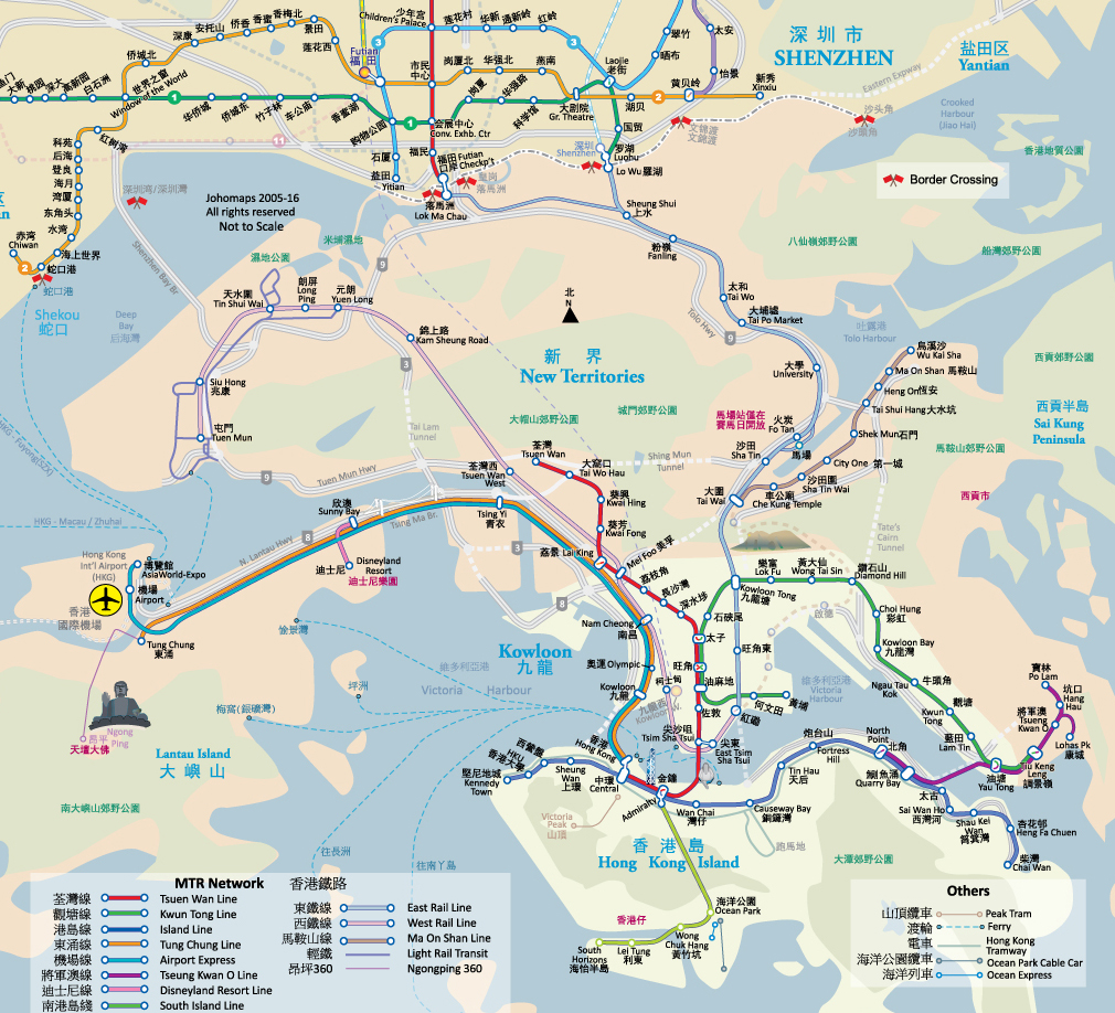
http://johomaps.com/as/hongkong/hkmetro_ch.html
It is a subway map for Hongkong. It shows 12 lines with different colors and shapes, transfer points, and also the shape of continent in Hongkong and the location and distribution of land and ocean. This map is special because it also contains several images of Hongkong's famous places of interest, such as Wong Tai Sin and Victoria Peak. It is really convenient for tourists as it also shows the connection with ShenZhen's subway system.
订阅:
评论 (Atom)